Ajuste de la metodología para la formulación de la zonificación agroecológica y socioeconómica para los Planes Municipales de Ordenamiento Territorial (PMOT) en el Bosque Seco Chiquitano
Context of the study
One of the project goals Forest conservation and development in the Chiquitano Forest ecoregion (Bolivia and Paraguay) was the elaboration of Municipal Land Management Plans (MOP) of municipalities of the Chiquitania. According to the methodology, evaluation component within the territory, and Socioeconomic Zoning Agroecológica it is key to determining the suitability of the land and then to formulate the Land Use Plan.
Overall, the development of agro-ecological and Socio-Economic Zoning (AEZ) in almost most PMOT was based on the methodological guide for the formulation of PMOT in rural areas (UOT, 2001) and in more specific terms in methodological procedures and Socioeconomic Agro-ecological Zoning (ZONISIG, 2001).
Seeing that these methods are more suited to productive municipalities and biodiversity component is very weak, has designed an adjusted to the reality of the municipalities in the ecoregion methodology, which gives greater importance to the components of biodiversity and environmental quality .
Description of achievements
This methodology is divided into three stages, as detailed in the following scheme:
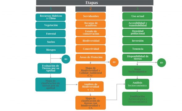
In the first stage, a land evaluation is done with the aim of knowing the land suitability. For it is considered the terrain and soils (physiography, topography, structure, physical-chemical composition of soils, climate, vegetation cover risks from natural and anthropogenic). The result is a preliminary zoning of the territory, in homogeneous units according to their suitability for use.
In the second step, in each unit using land evaluation, an analysis of the potential and limitations of biodiversity and environmental quality (easements, important sites for wildlife, conservation status, biodiversity, connectivity, areas it becomes natural protection and others). As a result of a new zoning analysis is achieved, also preliminary, with some changes of use in some units.
Finally in the third stage, as in the second, an analysis of socioeconomic variables (land tenure, land availability, population density, accessibility and walkability, current level of investment), the result leads to the Zoning Agroecológica done and Socioeconomic.
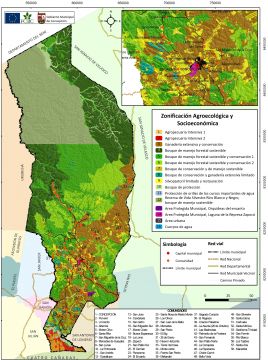
An example of the AEZ for the town of Concepcion, Santa Cruz, Bolivia is shown on the map. In this methodology, data management and assessment itself is a database designed in Excel, with the continued support of Geographic Information System (GIS) at the junction and transfer of spatial information.
Impact generated
Under the regional project, with this methodology it was possible to make a Agroecological Zoning 6 municipalities that incorporate elements of ecological integrity in its analysis and approach. In this sense, the component of biodiversity has been valued as the biophysical component (soil, vegetation, climate) and socioeconomic, allowing precise adjustment in the change in use. For example, in areas where land evaluation assigned to productive use, the presence of high biodiversity and important sites for wildlife have managed to change to use for conservation or allocation ecological protection areas such as easements. Also, the application of this methodology AEZ has also allowed the identification of areas as nature reserves to propose municipal character.
Lessons learned
The new methodology, initially, had a series of discussions where participation was key technicians with different specialties, so that through the critical analysis and consensus could be defined according to the principles of sustainability of municipalities the Chiquitano Forest ecoregion. It is also important to note that the Excel program initially had trouble processing large databases, precisely because GIS spatial information transferred was considerable (many polygons). This problem was corrected by minimizing the number of polygons without losing accuracy in the intermediate products of the design process of the AEZ. Methodology to function properly, it is important to have actual information and accurate, otherwise the results will not be as expected. It is suggested that a permanent quality control of information gathered in the field and office.
Steps for the Future
As the use of the program Excel has its limitations, it has been left raised automate this process, for which you should design a specific program and accelerate the process of AEZ, something which will keep the database updated and to make adjustments to lower cost and time of zoning in the municipalities and their PMOT.
References
[1] Land Management Unit, 2001
[2] Draft Agro-Ecological Zoning and Establishment of a Database Network and Geographic Information System in Bolivia.
Authors: Dulfredo Caba Espada, Merlot and Ruth Leon Anívarro (1)
(0) Comments
There is no content