Using climate information for supporting mung bean plantation over Sumbawa region
- Level: Advanced
- Time commitment: 1-2 days
- Learning product: Worked example
- Sector: Agriculture
- Certificate available: No
This article was developed during training with BKMG as part of a capacity-building project in Indonesia and the Philippines. Please have a look if you’re interested in the training slides.
Background
Sumbawa Island is one of the largest islands in West Nusa Tenggara (NTB), Indonesia and has a periodically dry savannah climate with rainy and dry seasons,and is also influenced by El Nino and La Nina. The temperature ranges between 21.4C and 34.3C, the precipitation ranges between 0 and 446 mm/month and the humidity ranges between 67% and 89%. Geomorphologically, Sumbawa is a volcanic island that consists of mountains, terraces, plains, valleys and rivers with the elevation between 0 and 1730 meters above sea level (BPS Sumbawa, 2013). The lower regions have large grass plains, which are punctuated by shrubs and trees while the remnants of ancient forests are found here. The hilly uplands have savannah and forests. The island has the area of 15,448 square km but large areas are covered only bythorn bush because shifting cultivation followed by grazing was long practiced here. Agriculture is one of the strategic economic sector with employment that is high in this region. The three agricultural commodities with the highest production are rice, corn, and mung beans.
Mung bean is a tropical plant that is suitable in low land where elevation is between 0 and 750 m above sea level, the range of precipitation is between 50 and 200 mm/month, and the temperature is between 25 and 27C. It is cultivated in rotation with other crops such as rice and maize. Kacang hijau, a local mung bean, is one of the five most produced and consumed crops in Indonesia following rice, corn, soybeans and peanuts. According to the Ministry of Agriculture (2014), Indonesia produced an average of 272,183 tons of Mung Beans for the past five years and it was produced 238,942 tons in 2014. NTB is the third largest producer of mung bean in Indonesia following Central and East Java Provinces (BPS, 2013) and within NTB, mung bean is cultivated most on Sumbawa Island. Mung bean is planted in monoculture during dry season. Some farmers also plant mung bean in the wet season in the drier areas of the island (USAID, 1989). BPS data show that 43,255 ha of land was dedicated to mung bean cultivation in 2010, but this is decreasing, and with it production totals. Several reports indicate that the decreasing production of mung bean and other secondary crops is related to shifting climate condition in NTB province and Indonesia in general. According to the Department of International Development (DFID) in 2007, Indonesia is predicted to experience more rain with the change of 2-3 percent per year. The intensity of rainfall will increase but the number of rainy days will become shorter and increase the risk of flooding. The volume of rainfall can significantly affect the production of mung bean (Ayinato, 2013).
As it is well known that climate plays an important role in the production of mung bean, it is important to conduct more assessments on climatic factors including the current conditions and the projected trends. This article aims to provide information to readers on the use of climate information for supporting mung bean cultivation – particularly over the Sumbawa region.
Current Climate
During 1977-2007, Sumbawa has a longer dry season, i.e. April to November and shorter rainy season, i.e. December to March (Figure 1). The wettest month has historically been February, with a monthly average of more than 220 mm between 1977 and 2007. On the other hand, the driest month has historically been August with almost no rain. Historically, the minimum average temperature recorded was 21.39OC in July, while the maximum average temperature was 33.37OC in October.
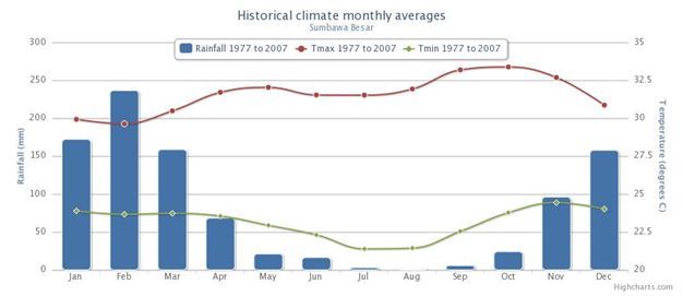
Figure 1: Historical climate monthly averages in Sumbawa Besar.
As shown in Figure 2, the data between 1977 and 2007 indicate that historically total monthly rainfall peaks have predominantly occurred during the rainy season (December and February), but there has been remarkable rainfall varied over the years. The records show months with particularly high rainfall, with totals of more than 400 mm, e.g. December 1977, February 1986 and February 1991. The drought period at Sumbawa has occurred in 1999 to 2002.
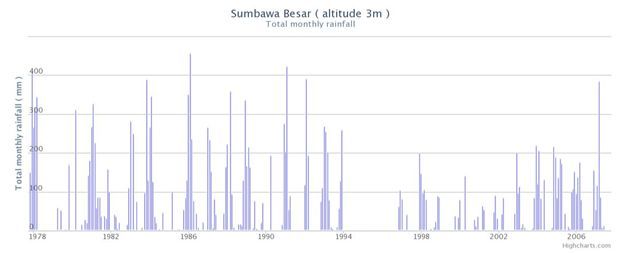
Figure 2: Total monthly rainfall, Sumbawa Besar during1977-2007. There is clearly wet and dry seasons, but the amount of precipitation changes over the time.
FUTURE CLIMATE PROJECTION IN SUMBAWA
The quick assessment was conducted with downscaled SRES GCMs for Sumbawa using the A2 and B1 scenario.
Both projections below imply some changes in the period of 2046 to 2065. The result of Scenario model SRES A2 and B1 almost have the same pattern where the dry season (April – October) monthly precipitation shows little change compared to historical level. In contrast to the rainy season (November – March) monthly precipitation is expected to change either direction in different magnitude.
In general A2 and B1 scenario has a similar pattern, so we use the A2 scenario (high emissions). We looked first at medium to long-term projection, as our goal is to know how the climate risks may evolve in the longer term, to ensure that medium-term choices are sustainable in the longer term, so we also look at the projection for the period of 2046-2100 as shown in Figure 5.
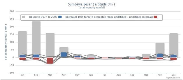
Figure 3 Projected changes in total monthly rainfall scenario SRES A2, Sumbawa Besar, 2046-2065.
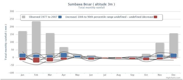
Figure 4: Projected changes in total monthly rainfall scenario SRES B1, Sumbawa Besar, 2046-2065
Looking at the projections for 2046-2065 and 2081-2100, it can be seen that both projections show similar patterns. Total monthly rainfall is expected to decrease in the dry season from April to November, so that the dry seasons will become drier in Sumbawa. Compared to the dry season, there is greater variation in changes projected for the rainy season. About half the models predict an increase in rainfall, and the other half predict a decrease – changes in monthly precipitation are uncertain.
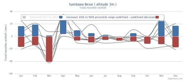
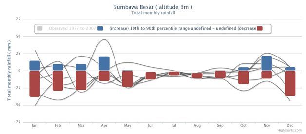
Figure 5. Projected change in monthly rainfall data using SRES A2 for future period 2046 – 2065 (top) SRES A2 for future period 2081 – 2100 (bottom)
LOOK AT DATA FOR OTHER NEARBY STATIONS
Looking through the data of the Bima station, its future climate projections suggest the similar patterns to our earlier interpretations for the Sumbawa station, except in August. During August, the rainfall pattern in Bima is increasing, but at Sumbawa it is decreasing. However, when we compare with the Mataram Station, the future climate projection is quite different. This difference may be influenced by the type of the area such as rural and urban and topography. Mataram is an urban area and Sumbawa is a rural area.
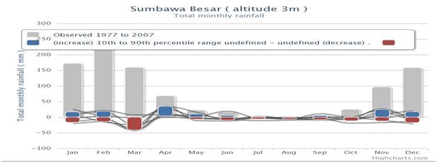
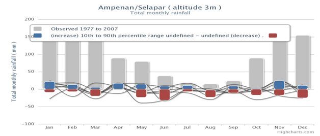
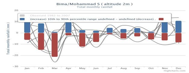
Figure 6: Projected change in monthly rainfall data using SRES A2 for Sumbawa (top), SRES A2 for Ampenan (middle) SRES A2 for Bima (bottom)
CLIMATE INFORMATION FOR MUNG BEAN PLANTATION
According to land suitability as shown in Table 1 and historical climate monthly average (Figure 1) Sumbawa is suitable for the cultivation of mung beans from a climate perspective, (although rainfall is less than optimal), but the productivity of mung bean in Sumbawa was still above the average for Indonesia (BPS, 2013). This possibility because the water requirement for mung bean plants is only critical at the beginning of its growth and flowering phase (approximately 1 month after planting). The minimum required water in the critical period equivalent to rainfall of 100 mm/month and Sumbawa has a rainfall of more than 100 mm/month from November to March. Mung bean is very suitable to be planted in the regions that have rainfall of 350-600 mm / month. However, high rainfall will lead the crop easy to fall and plant diseases.
Table 1 Land Suitability Class of Mung Bean
|
Characteristics |
Land Suitability Class of mung bean |
|||
|
S1 |
S2 |
S3 |
N |
|
|
Average temperature (oC) |
12-24 |
24-27 10-12 |
27-30 8-10 |
>30 <8 |
|
Rainfall (mm) |
350-600 |
600-1000 300-350 |
>1000 230-300 |
<230 |
|
Humidity |
42-75 |
36-42 75-90 |
30-36 >90 |
<30 |
Source: Research and Development Agency, Ministry of Agriculture of the Republic of Indonesia
Projected changes in total monthly rainfall under the SRES A2 scenario for 2046-2065, as shown in Figure 3, show that rainfall changes will only have a small impact on the production of mung beans.Projected changes in total monthly rainfall scenario SRES A2 in Sumbawa Besar for the period of 2046-2065 as showed in Figure 3 above, states that the total monthly rainfall in that period will only have a slight impact on agricultural mung beans.To increase the production of mung beans in Sumbawa, it is recommended that the government builds better irrigation system to ensure the availability of water for the crops and also create new varieties that are more resistant to drought. Especially, there is a reasonable chance that Sumbawa get drier, so it is important to consider adaptation plans for for mung bean.
REFERENCES
Ayinato, S.E. 2013. Kajian Dampak Perubahan Iklim terhadap Produktivitas Kacang Hijau (phaseolus radiates l.) di Lahan Kering. http://eprints.umk.ac.id/89/1/KAJIAN_DAMPAK_PERUBAHAN_IKLIM.pdf
BPS (Indonesia Statistical Bureau). 2013. Indonesia in Figure 2013. Online available onhttp://www.bps.go.id/tnmn_pgn.php?kat=3&id_subyek=53¬ab=0
BPS. 2013. Statistik Daerah Kabupaten Sumbawa 2013 (Regional Statistic of Sumbawa 2013). Online available on http://sumbawakab.bps.go.id/index.php?page=viewpublikasi&act=pub&publikasi_id=27
Kementerian Pertanian Republik Indonesia (Ministry of Agriculture of Indonesia). 2014. Production of mung beans by location. http://aplikasi.pertanian.go.id/bdsp/newlok.asp
Research and Development Agency, Ministry of Agriculture of the Republic of Indonesia. http://bbsdlp.litbang.pertanian.go.id/
Skalanews. (2014). Produksikedelai NTB bakalturun 4.382 ton. http://skalanews.com/berita/detail/197700/Produksi-Kedelai-NTB-Bakal-Turun-4382-Ton
United States Agency for International Development (USAID). 1989. Agriculture in Sumbawa District (NTB). Environmental Assessment Tiu Kulit Dam. http://pdf.usaid.gov/pdf_docs/PNABJ015.pdf
Related articles
Effects of climate change on cacao production in Gorontalo, Indonesia.
(0) Comments
There is no content