Mapping Climatic Hazards in Nepal
Spatial dynamics
Translating indicators of vulnerability for exposure units/stresses as described above for populations at risk into vulnerability maps and then defining hotspots of aggregate vulnerability using available datasets of hazard events, highlight the zones withihn the country that face exposure to specific hazards.
Floods and landslides
Identify risk prone areas both temporally and spatially. A first step in the process of risk mapping in Nepal, for example, is to highlight the frequency and occurrence of floods and landslides across the country.
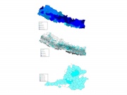
Landslides

Number of floods, casualties and cost
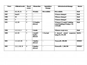
At the local level events observed in the ACCCA case, Syangja district are tabled below:
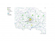
Total flood and landslide events for districts around and including Syangja district
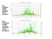
Comparison of precipitaion for extreme years of 1995 and 1998 compared with long term norm.
Related Pages
Background to ACCCA Nepal Project
Background on Disasters in Nepal
Nepal Vulnerability Assessment
Nepal Assessing Conditions and Trends
Understanding trends in climate in Nepal
Other work on Adaptation in Nepal:
Practical Action: Promoting Adaptation in Nepal
Recorded events and impacts for Syangja district
Recent frequent dry spells and its impact in Nepal
If we look at the current disaster perception in Nepal, dry spells or droughts have not been officially identified as the disaster. The disaster report published by authority on disaster management, MoHA and DWIDP, have not incorporated drought as a disaster. Nevertheless the country has experienced bad years in the past prior to 2000 in 1972, 1977, 1982 and 1992. Since last few years, starting from 2002, Nepal is experiencing frequent dry spells. During the years 2002, 2004, 2005 and 2006 the country faced dry spells during monsoon and winter seasons. Except in the year 2005 when the whole country experienced severe drought, in the remaining years, half of the country (either eastern half or the western half) has experienced dry spell. The impact of these droughts is mainly on agriculture production. And sometimes these droughts have been followed by the floods and heavy rainfall, which is more disastrous to the agriculture production. Therefore since last few years agriculture production is being impacted by these dry spells. A few examples are listed below:
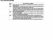
Drought events
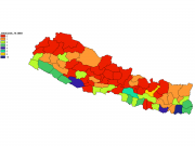
Number of droughts 1974 to 2003
Temporal dynamics
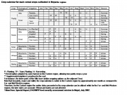
Crop calendar for regions of Nepal
Historical analysis
Climatic variability poses significant repercussions for agricultural production, but its spatial and temporal manifestations are considerably varied. The diagnostic capacity to investigate these impacts can be significantly increased by coupling detailed historical meteorological data with innovative analytic methods. On the basis of available data and information, it is possible to analyze the conditions and trends in climate parameters, from the most basic data (e.g. maximum and minimum temperature and rainfall), to more elaborate indicators (duration of the growing season), to complex indices (satisfaction index of water requirements for the growing season) to allow the identification of important thresholds and trigger points on short and medium time scales. This information can be used to assess potentially impacts and identify anticipatory adaptation measures. If this data are not available, it is possible to consult global and regional databases that provide monthly averages for a variety of climatic parameters.
Climatic variability poses significant repercussions for agricultural production, but its spatial and temporal manifestations are considerably varied. The diagnostic capacity to investigate these impacts can be significantly increased by coupling detailed historical meteorological data with innovative analytic methods. On the basis of available data and information, it is possible to analyze the conditions and trends in climate parameters, from the most basic data (e.g. maximum and minimum temperature and rainfall), to more elaborate indicators (duration of the growing season), to complex indices (satisfaction index of water requirements for the growing season) to allow the identification of important thresholds and trigger points on short and medium time scales. This information can be used to assess potentially impacts and identify anticipatory adaptation measures. If this data are not available, it is possible to consult global and regional databases that provide monthly averages for a variety of climatic parameters.

Frequency of days with more than 100mm rainfall
Comparison of precipitaion for extreme years of 1995 and 1998 compared with long term norm.
Related Pages
Background to ACCCA Nepal Project
Background on Disasters in Nepal
Nepal Vulnerability Assessment
Nepal Assessing Conditions and Trends
Understanding trends in climate in Nepal
Other work on Adaptation in Nepal:
(0) Comments
There is no content