A combined cognitive and spatial model to map and understand climate-induced migration
Summary
Climate change impacts on populations have increased the number of affected people and climate migrants worldwide. Although the nexus between climate change and migration is not monolithic, analyses of individual-level factors at the local scale that reveal the specific drivers of migration are lacking. Here, we show that people are motivated by individual calculations, prioritizing economic and social factors when migrating.
We used data from 53 structured interviews to deconstruct the assessment of the decision-making process of people deciding to migrate from a region highly vulnerable to climate change, assessing the internal and external migratory potential.
The evaluation of migration potential evidenced that potential migrants react and make decisions based on perceptions and preferences among economic, social, environmental, and cultural factors when migrating and value these factors differently. Our spatial multi-criteria model reports disaggregation in that people prioritize economic factors, such as unemployment, job opportunities, and lack of income, over other migration-related factors. In contrast, environmental factors are generally considered underlying.
This article is an abridged version of the original text “A combined cognitive and spatial model to map and understand climate‑induced migration“ published in Environment, Development and Sustainability, under theCC BYlicense in February 2023 © Cárdenas-Vélez. Please note that references have been removed.For more detail, full references, and to quote text please use the paper available for download on the right.
Method
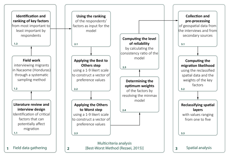
The study used a combined cognitive and spatial model to map and understand climate-induced migration. The methodology used in this study involves individual interviews as data collection instruments, multi-criteria analysis using the Best-Worst method (BWM), and spatialization of the model. The study area is the municipality of Nacaome in the department of Valle, Honduras, which is in the Central American Dry Corridor. The Dry Corridor area comprises various ecosystems in Mesoamerica’s tropical dry forest ecoregion.
The study used a systematic sampling and interview overview to analyze the decision-making process of migrants in Nacaome. The interview protocol consists of 28 semi-structured questions that collect information about the households’ composition, economic activity, livelihoods, demographic characteristics, and information associated with the historical migration dynamics of the people who compose it.
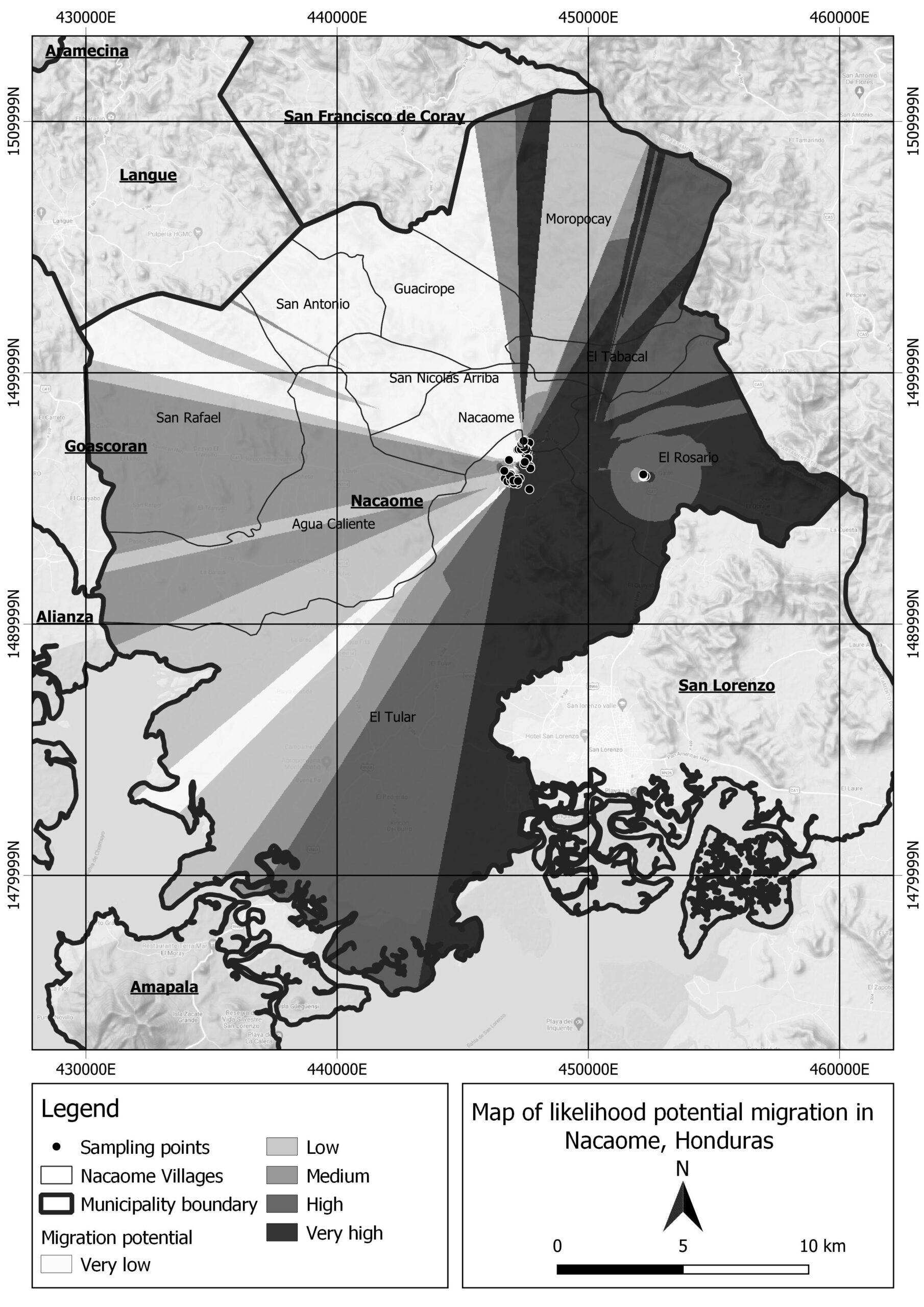
Finally, the spatial model was developed by processing social, economic, and environmental spatial information through spatial layers in QGIS. Using the multi-criteria model, a cross-analysis of spatial and cognitive data was performed to produce a probability map of potential migration areas in Nacaome (shown in Figure 5). It reveals the spatial disaggregation of different responses to the myriad of factors involved in the migration decision-making process and reveals that not all individuals or communities at risk tend to migrate, even at the municipal scale. By identifying the variables that lead people to migrate and the areas of high migration potential, the model can help policymakers take targeted and tailored actions to address climate change-related migration effectively.
The methodology workflow is presented below:
Key Findings
1. Economic and social factors are the primary drivers of migration: The study found that economic and social factors, such as job opportunities, income, and family ties, are the most significant drivers of migration in Nacaome. Environmental and climate change-related factors were considered tertiary elements in the decision-making process.
2. Gender differences in migration decision-making: The study found that men and women prioritize different factors when deciding to migrate. Men were more likely to prioritize economic factors, while women were more likely to prioritize social factors, such as family ties and community support.Nonetheless, women (68%) and men (73%) both considered unemployment a key factor when deciding to migrate.
3. No single driver of migration: The study found no single driver of migration but rather a combination of factors influencing the decision to migrate. The authors suggest that policymakers must take a holistic approach to address the underlying problems associated with climate migration.
4. Spatial multi-criteria model: The study used a spatial multi-criteria model to map the likelihood of potential migration areas in Nacaome. The model allowed for a spatially explicit representation of the variation in migration potential within the municipality.
Reflections and Outcomes for Policymaking
The dynamics of migration decision-making are characterized by social, economic, environmental, political, and demographic factors. Our findings and model highlighted this the local and individual level, potentially providing launching pads for public policymaking on social, economic, and environmental vulnerability and helping to achieve the SDGs. The knowledge gained from this method can contribute to program creation, prioritization, and policy formulation to reduce the underlying vulnerabilities of local populations.
Furthermore, we argue that it is essential to encourage academics and decision-makers to identify the elements that influence climate migration locally to avoid losing the specificity of indicators assessed at the regional or national scale, such as personal circumstances, local networks, mobility capacity, and resources.
Suggested Citation:
Cárdenas-Vélez, M., Barrott, J., Betancur Jaramillo, J.C. et al. A combined cognitive and spatial model to map and understand climate-induced migration. Environ Dev Sustain (2023). https://doi.org/10.1007/s10668-023-02987-7
Related resources
- Island Stories: Mapping the (Im)mobility Trends of Slow Onset Environmental Processes in Three Island Groups of the Philippines
- Migration, environment and climate change: Responding via climate change adaptation policy
- The Big Climate Movement
- Notions of climate-induced (im)mobility decision-making and wellbeing in an urban informal settlement in Bangladesh
(0) Comments
There is no content