EcoAdapt project: Socio-institutional context analysis
Introduction
As global warming continues many Latin American countries face critical water scarcity issues. In particular, rural communities in the region are highly vulnerable because they rely on limited freshwater resources for their main livelihoods. However, future vulnerability of water resources in the region is not determined by climate change alone. In addition to changes in weather and climate, important drivers of increased vulnerability are environmental degradation, demographic pressure, political dynamics, migration patterns, unplanned urban growth, increased economic inequality, low investment in infrastructure and services, and poor inter-sectorial cooperation.
To cope with possible future impacts caused by the combination of these drivers, some countries have made efforts in developing adaptation strategies, particularly through conservation of key ecosystems at the landscape-level. However, evidence thus far shows that little progress in implementing adaptation strategies has been made both at national and sub- national levels. Slow progress relates to, amongst other things, initiatives motivated by external sources, which adopt a top-down approach and face difficulties in designing context-tailored strategies that are able to reduce possible long-term impacts.
To address the above challenge, EcoAdapt adopts a different approach. We consider adaptation planning for water resources as a bottom-up process that requires ways to share and co- generate knowledge between scientists and multiple stakeholders operating across different scales and policy areas through an iterative process of learning. In this regard, we assume that water resources adaptation planning for local development needs to be embedded in a multi- scale and multi-sector environment working with and expanding existing networks that link different spatial scales and knowledge domains. To achieve this, we are working with three civil society organizations that represent multi-stakeholder platforms called Model Forests (MFs). The three MFs engaged in EcoAdapt are located in Bolivia (Model Forest Chiquitano), Argentina (Model Forest Jujuy), and Chile (Model Forest Araucarias de Alto Malleco).
Adopting a bottom-up approach for water planning to design context-tailored adaptation strategies through science-society engagement requires building on the basis of a good understanding of the socio-institutional context. This report is a comprehensive synthesis of the socio-institutional context analysis generated during the first phase of the project (May 2012 to May 2013). It includes a transversal analysis of the three Model Forests in EcoAdapt.
Methodology
The methodology used for the socio-institutional context analysis was co-constructed with the Model Forests because we recognise the importance of integrating the knowledge of relevant local actors in the co-generation of legitimate knowledge for development of socially appropriate strategies in the landscapes, while maintaining credibility of science (Shaw and Kristjanson 2013). The methodology included several methods, which were adapted to the context of each Model Forest. The methods involved semi-structured interviews, social network mapping (read more below), workshops to validate results, participant observation, and the identification of strengths and barriers to water resources adaptation planning in each Model Forest (see Figure 3-1). Results were analysed together with the Model Forest teams, who play a key role in contextualising the findings. Preliminary results of this analysis were presented and discussed in synthesis workshops, which provided a space for reflection and helped further complement the analysis presented here.
Overall, the process of co-constructing the methodology and working together on the analysis presented in this document was iterative and required time, commitment and trust building. We believe that a more in-depth understanding of the socio-institutional context could only be gained if traditional social science methods were co-managed and strategic alliances were co-built with partners who are embedded in their territory. This interaction promoted exchange of new information, and facilitated learning and shared understanding, which build relevant capacities and the basis for joint future action in the landscapes (Pahl-Wostl et al. 2007).
Figure 3-1 illustrates the different social methods applied in the socio-institutional context analysis divided into three phases. Each phase builds on the previous one. The fieldwork phase, which took place for most part of 2012, was followed by a phase of analysis and validation of preliminary results with local actors in the landscapes. This validation was possible through workshops implemented in each MF at the end of 2012. Following validation workshops the analysis continued together with the Model Forest teams. This third phase included the identification of conditions that may enable or constrain the adaptation planning process in the landscapes. New results were presented and discussed in April 2013 at synthesis workshops in the MF landscapes.
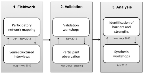
Figure 3-1 from report, page 18: Methods implemented in three phases for the socio-institutional context analysis
Social network mapping
In this particular analysis, we applied participatory network mapping (SNM) as a method to explore relationships between the different actors that are relevant to the governance of water resources in the Model Forests. The information and local knowledge elicited through the participatory mapping is of value to understand the interactions between actors, local perceptions about the influence different actor have on decision making for water resources, and existing capacities and weaknesses to that need to be overcome. This approach also helped us to identify central and bridging actors in the network and understand who dominates the decision space in relation water resources planning and management in the landscapes. The findings also contribute to the identification of potential ‘agents of change’ who can have influence on the decision space and facilitate collaboration through information and knowledge exchange (Crona and Bodin 2006) and mobilization of resources (Carlsson and Berkes 2005) between different actors and governance levels in the network.
Read more about social network mapping on weADAPT here
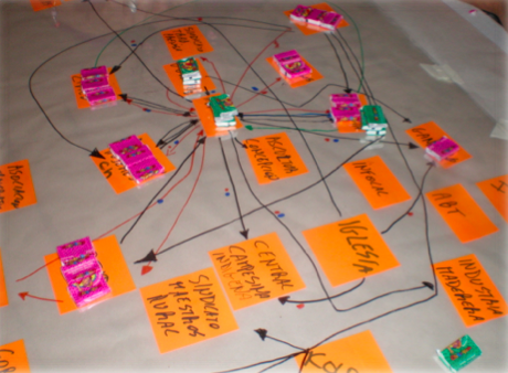
Network map showing different information flows (arrows) and influence levels (coloured blocks for formal and informal influence), working group of the private sector in the MFC.
Water resources in the landscapes
Understanding how local population and key actors perceive the current situation of water resources in the landscapes helps to gain i) a broad perspective on the drivers affecting these resources and potential future problems that may arise if current trends continue into the future, and ii) a deep understanding of what are main issues that local population perceive and is interested in addressing. This also helps contextualize the analysis of barriers and strengths to water resources adaptation processes, and of possible entry points that could be explored to improve the management of water resources to prevent possible future problems. Moreover, current trends help gain basic understanding of the interplay between humans and water resources in the context of their environments (complementing the work in Task 2.5). This section has been developed based on interview insights gained from multiple informants in the MFs over 2012 and is the basis for the analysis in the next sections.
Current situation
Although each territory is one of its own, there are commonalities between the three Model Forests around current drivers affecting their water resources. To varying extent, increasing competition for water resources is already posing a challenge in terms of availability of good quality water in all three landscapes. The demand side of this challenge is represented by a growing population and development practices that are altering land use patterns, degrading the natural resource base and as a result changing the composition of the landscape. The supply side of this challenge relates either to biophysical factors such changes in water flows due to decreased precipitation, diversions or sedimentation processes, or to social factors such as regulatory frameworks that lead to an uneven access to water resources, or water contamination caused by anthropogenic activities. In all cases, feedbacks between these processes exist and will be further exacerbated in the future if these drivers continue building and converging and are joined by new ones such as changes in the climate regime.
Strengths and Barriers for Water Resources Adaptation
The interviews, network mapping and validation workshops helped identify a series of conditions that could constrain or enable water resources adaptation planning processes. The analysis on strengths and barriers for water resources adaptation planning presented in the report was conducted in collaboration with the three Model Forest teams. As actors embedded in their landscape and deeply involved in fostering dialogue and collaboration, they are key in contextualising the findings and hence, in helping deepen the understanding of the socio- institutional context. This understanding is the basis for building on synergies between already existing strengths that could allow overcoming current barriers to the process. Furthermore, such an analysis helps identify possible entry points, which could be considered as first steps or pilot actions in the process of fostering positive change in the landscapes.
Barriers: factors obstructing water resources adaptation planning
- There is a lack of some notion of the spatial dimensions of the basin and where the different local actors are located in it.
- In different parts of the basin, the problems around water resources are different. In the urban area, located in the middle of the Zapoco river basin, the main problems relate to water contamination and sedimentation levels of the water dam, while in the rural area, problems relate to changes in river flows during the dry season or due to micro dams in farmlands, erosion, and river water contamination from mining and forestry sectors.
- The water stress signal differs in the three Model Forests. While in the MFC and the MFJ physical water scarcity is a current issue due to water contamination and changes in the hydro meteorological system, this is not the case in the MFAAM where actors argue that a threshold has not been reached for water to be perceived as scare due to a lack of physical availability.
- There is a lack of technical studies in the landscapes investigating hydrological, climatic and land use dynamics. And there is not a good understanding about the impacts of different human activities on water resources.
- There is a lack of access to existing information. Also, often information is given in such a format that it cannot be assimilated by the user.
- A barrier mentioned in all three landscapes is the general lack of a common vision for the future of water resources.
- Actors highlighted a lack of inter-institutional collaboration either between different types of actors, between public entities, or between spatial scales.
- The lack of collaboration is further hampered by the lack of clarity on the roles and functions of public institutions in relation to water resources, and socio-political dynamics in the landscapes, which re-shape the network of actors. Weak collaboration also related to passive attitudes among the local actors in the landscapes. In the MFJ, passive attitude seems to be related to a general lack of environmental awareness and values attached to nature, particularly among adults (i.e. changes have been noticed among the younger generations), which has resulted in a culture that is more reactive when it comes to environmental issues.
- Finally, a further barrier that is common to all sites, is the lack of implementation of the regulatory framework. This can result from different problems such as contradictory rules, poor implementation and regulation capacity, lack of knowledge about the regulatory frameworks and problems with the regulatory frameworks themselves.
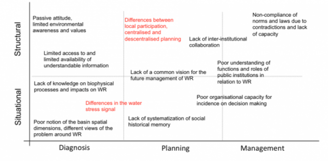
Figure 6-1 from p. 46: Barriers to the water adaptation planning processes in the three Model Forests. Common barriers in all three sites are shown in black, differences in red. WR = water resources
Strengths: factors enabling water resources adaptation planning
- One of the main strengths shared amongst the three landscapes is the recognition of early warning of ecological signals. In all MFs, actors recognise disturbances in the landscape with ecological impacts such as deforestation patterns, erosion problems, and over- exploitation of resources. They also acknowledge a change in the precipitation patterns and an increase in temperature over the past decades, with consequences on the production calendar. Actors in all three MFs also recognised the increase in competition for water resources in their landscapes.
- Equally important is the recognition in all three MFs of the linkages between water, forests, land and climate, although the mechanisms behind these linkages are not well understood.
- A strength across all sites is the existing interest in generating, exchanging and improving knowledge and understanding about water resources.
- Furthermore, all three MFs have existing capacities on which to build for better water resource management.
- An additional strength, that is not equal in all sites, is the existence of legal frameworks that support local participation in the planning process.
- Finally, strengths that are not common to all sites but are important instruments for future water resource management are the existing protected areas around key water bodies in the MFJ and MFC.
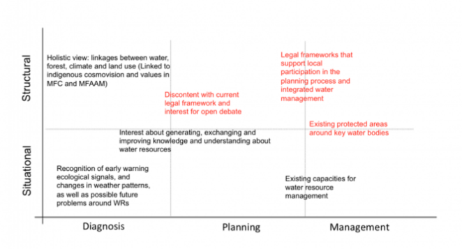
Figure 6-2 from p. 46: Strengths in water adaptation planning processes in the three Model Forests. Common strengths in all three sites are shown in black, differences in red.
Lessons learned throughout the process
Several insights have been gained in this first phase of the project working together with the MFs. Lessons learned are important inputs to consider in future project activities, as they provide insights about processes of interaction in the landscapes that can contribute to continued collective learning, collaboration and ultimately positive change.
The co-construction of the socio-institutional context analysis (i.e. from method design to analysis) enables the integration of local and scientific knowledge through an iterative process of constant exchange between MFs and scientists. This first phase of the project required a significant investment of time for fieldwork and later on for validation, collective analysis and writing in each Model Forest. This process of co-construction allowed the generation of project impacts along the way and not only at the end of the process.
On the one hand, this process of co-construction promoted empowerment among the local actors who participated in the MFs. Local actors, particularly potential agents of change, are engaged in a process that goes beyond a consultation. They are engaged in a process where they adopt the lead role in achieving the desired change that EcoAdapt would like to promote in the landscapes. In this sense, the process of co-construction also promotes ownership and commitment, which are key to support a bottom-up process for adaptation planning in the landscapes.
On the other hand, scientists and civil society working together facilitates collective learning and in some instances development of new skills. The exchange of knowledge was possible through different channels, either through face-to-face interaction during workshops or field visits to the MFs, or through virtual settings such as Skype meetings. This exchange alsocontributes to trust building, which is essential for long-lasting partnerships and the next phases of the project.
Of course, there are also challenges inherent to the participatory process of the co-construction of knowledge. One of the main challenges is time. These processes are very time-intensive due to the iterative nature of learning. Time investment is also a requisite if adaptation strategies developed in the territory are going to be long lasting, legitimate and supported through a bottom-up process.
Another challenge is balancing differing interests in the process and unexpected changes along the way. This requires adaptive management and sometimes lowering scientific-academic expectations. Political dynamics in the landscapes sometimes have effects on actors and decisions, which are not possible to control. These challenges need to be accounted for with flexibility, to find way to adapt and still achieve the desired outcomes.
In terms of interaction with the broad spectrum of actors in the landscapes, we learned that in some instances, the workshop format generated false expectations among participants, creating tensions in a project that is mainly focused on research. Although the workshops promote collective learning, there is a need to find other feedback channels that facilitate knowledge sharing without necessarily generating misleading expectations. For example, in the MFJ the team suggested shorter meetings among three or four actors, and the MFC is already implementing community transects and field trips as alternative ways to exchange knowledge.
Finally, this initial phase of the project was the first opportunity to generate interest around water resources in the landscapes. Social networks concerned about this topic (e.g. the Grupo Impulsor in the MFC) are slowly emerging as a result of this first phase of work. The next phases of the project will require even more interaction with these groups of actors (i.e. identified as ‘agents of change’) and validation with the general public to work jointly in the generation of future scenarios and socially accepted adaptation strategies at the landscape-level.
Conclusion and next steps
The present socio-institutional context analysis is the foundation of future activities in the project, which aim at facilitating bottom-up processes to develop long-lasting, context-tailored adaptation strategies in the landscapes. Firstly, this document integrates local knowledge and differing perspectives from stakeholders about the current situation regarding water resources, including different interests and observed trends, which may lead to conflicts in the future.
Secondly, the analysis identifies key actors and network relationships that are key to consider in the adaptation planning process. By mapping water governance networks, we identify key actors that play a central role due to either the number of connections to other actors in the network, their influential role in the decision making process around water resources, or because they are important bridges between spatial scales or actor types with differing interests. Based on this analysis and discussions at validation workshops we also identify ‘agents of change’, who are considered allies of the project because they represent attributes that help influence key actors in the governance networks and generate the desired change in the landscapes that the project would like to promote.
Thirdly, the socio-institutional context analysis highlights conditions that may facilitate or hinder water resources adaptation planning in the landscapes, as well as entry points that build on existing strengths. These entry points could be considered first steps or pilot actions that could support bottom-up processes for water resource adaptation in the MFs.
Suggested citation
Devisscher, T., Coll Besa, M., Vignola, R. 2014. EcoAdapt Deliverable 2.4: Socio-institutional context analysis
Main document
The three Model Forests sites
The cross-site Socio-institutional context analysis was based on three Model Forests studies. See links below to read more about each site:- For the case study Model Forest Chiquitano in Bolivia, look here.
- For the case study Araucaria Model Forest of Alto Malleco in Chile, look here.
- For the case study Jujuy Model Forest in Argentina, look here.
Further resources
- Access here: EcoAdapt –Summary Deliverable 2.4
- Access here: EcoAdapt’s Newsletter: Ecos del Agua, Boletín Julio 2014, 2da edición
Suggested citation
Devisscher, T., Coll Besa, M., Vignola, R. 2014. EcoAdapt Deliverable 2.4: Socio-institutional context analysis
The three Model Forests sites
The cross-site Socio-institutional context analysis was based on three Model Forests studies. See links below to read more about each site:
- For the case study Model Forest Chiquitano in Bolivia, look here.
- For the case study Araucaria Model Forest of Alto Malleco in Chile, look here.
- For the case study Jujuy Model Forest in Argentina, look here.
View more EcoAdapt project outputs:
EcoAdapt Project: Cross-site Analysis of Ecosystem Based Adaptation in South America
EcoAdapt project – Working paper on social dynamics during adaptation planning
EcoAdapt project: Lessons Learned from the Analysis of Socio-Ecological Dynamics
EcoAdapt project – Working paper on social dynamics during adaptation planning
iModeler manual: a quick guide for fuzzy cognitive modelling
Cronología de los cambios en el paisaje de la región de la Araucanía desde 1850 hasta 2013
(0) Comments
There is no content