SCA-Himalayas project-Landslide analysis with radar data in the Indian Himalayas
Summary
Communities in mountain regions depend on nature and its resources. At the same time they are highly exposed to the threats of natural disasters particularly landslides, glacial lake outburst floods (GLOFs), droughts, which increase with the effects of climate change. The SDC project Strengthening Climate Change Adaptation in the Himalayas (SCA-Himalayas) addresses these challenges by supporting the Indian Himalayan States through technical assistance by Swiss and national experts from universities, private sector and NGOs. The project interventions relate to the management of surface and springs water and disaster risk management.
Objectives and partnerships
The objective of the SCA-Himalayas project is to integrate climate actions into national and sub-national planning and implementation, benefitting local communities. The SDC has been engaged through projects in the Indian Himalayas since 2011, in the frame of its Global Programme Climate Change and Environment (GPCCE). The SCA-Himalayas project supports Indian Himalayan states to understand sectoral vulnerabilities and to implement adaptation actions. The project is now in its second phase with a thematic focus on Disaster Risk Management (DRM) and water resource management in the states of Sikkim, Uttarakhand, Himachal Pradesh and Manipur. Pilot interventions are implemented in close collaboration with the State Governments as well as the Central Government, such as the National Disaster Management Authority (NDMA), the Ministry of Environment Forest and Climate Change (MoEFCC), Department of Science and Technology (DST), and the Ministry of Jal Shakti. Further, Swiss, international and national experts from universities, private sector and NGOs ensure the required technical expertise.
Download a factsheet on the project
Background
This article refers to an assessment for improved disaster risk management in the State of Uttarakhand, in an area named Bhagirathi Valley. Bhagirathi Valley has over 600,000 residents and more than 6 million pilgrims and domestic tourists, since it is the source of the holy river Ganges. The 200 km long valley is characterized by a high geographic variability with altitudes ranging from 350 m to 5000 m – and difficult access. The Valley has been selected by the State government as one of its hotspot areas, due to the high number of exposed people but also the impacts of climate hazards. Climate change has led to an increase of number and intensity of landslides, but also flash floods, glacial lake outburst flooding (GLOFs). Climate change also affects the water resource availability and river flows for mountain communities as well as downstream populations.
Landslides are a major threat for the people and infrastructure. Every year, particularly during monsoon season roads are closed, villages cut off and accidents occur due to landslides. Multiple events in Uttarakhand – often associated with cloudbursts – have caused significant damages and losses. One of the worst events in Indian history occurred in 2013 in Kedarnath valley with over 5,000 deaths due to cloudbursts, consecutive landslides, mudflows and flash floods. Also in summer 2022 several people lost their lives due to landslides, which are particularly dangerous for travellers along the exposed mountainous roads. In early 2023 an event in Joshimath in Uttarakhand hit the headlines. The town, with over 25,000 residents, is located on an unstable subsidence zone. Major soil movements caused serious damages to buildings and required the evacuation of hundreds of people.
Using digital technology with SAR data to assess landslides in Bhagirathi
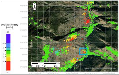
To assess the landslide susceptibility in Bhagirathi valley SDC mandated the Swiss-based expert company Sarmap (https://www.sarmap.ch/) for a remote sensing study using Synthetic Aperture Radar data (SAR-data) from Satellite Sentinel-1, which are free and globally available. Through the method of Interferometry, SAR data from 2015 to 2020, taken in intervals of 12 days, was analyzed to identify surface deformations. With a precision of a few millimetres, the evolution of deformations, areas of (re-) activated landslides were mapped and correlation with external factors e.g. rainfall, were measured.
The results were presented as deformation-velocity maps (see Fig 1). This study of Bhagirathi valley shows that the lower part is generally stable. Most instable areas are in the middle upper part. For the highest areas the results were of limited precision due to vegetation, snow and slope orientation.
Lessons Learnt
Traditionally, landslide assessments rely on ground-based surveys. In mountainous areas this refers to time intensive, arduous work, exposing field workers to risks, often resulting in a bias towards easily accessible areas. SAR-data analysis offer an interesting digital approach to rapidly assess surface deformation over a large area. However, the study also indicated pockets with limited accuracy due to dense vegetation, steep slopes, hills oriented to the shadow of the satellite’s radar signal and the maximum detectable deformation. One of the key conclusions of the study – as summarized in a scientific article (cf. section further resources) – was that slow land movements related to landslides, typically; subsidence zones, can be easily detected while fast movements, such as debris-flow or rock falls are more difficult to analyse. With the improvement of satellite data – a new generation of Sentinel-1 data and a new Indian Satellite, the SAR technique offers great potential. Such rapid, low-cost analysis of unstable zones are very valuable for short term disaster risk management as well as for mid-term planning of buildings, roads and other infrastructure in order to avoid future disaster losses. The recent event in Joshimath, where a whole town is affected by land subsidence, is just one of many potential areas of application.
The SAR data analysis provided a useful overview of landslides in the whole Bhagirathi Valley to identify critical instable areas where an in-depth analysis is required. In the framework of the SCA-Himalayas project these results were further processed for the elaboration of a landslide susceptibility and precipitation based forecast model. The improved ability to map and model landslide risk could provide important scientific contributions towards the future development of a landslide early warning system.
Credit: Sarmap (https://www.sarmap.ch/) is the author of this SDC-funded study
Other articles of interest
- The Role of Risk Perception and Community Networks in Preparing for and Responding to Landslides
- Glacial lake outburst floods: A shared risk across the Hindu Kush Himalayas
- COPE Books for Children: Landslides
- Climate change adaptation in China: monitoring and early warning of glacial lake outburst floods in the area of Yarkant River
Other SDC articles :
- Climate Change Management Support in Peru
- Cambodia Horticulture Advancing Income and Nutrition (CHAIN) programme
- Andes Resilientes al Cambio Climático Project (Resilient Andes to Climate Change)
- The SDC’s Engagement for Clean Air for All
- Decarbonizing the building sector – 10 key measures
Visit the Adaptation at Altitute solutions portal
Related resources
- Landslide Monitoring through Sentinel-1 SAR Data (springer publication)
- Project web site
- SCA-Himalayas project information page
- Reducing the risk from Himalayan tsunamis: How global cooperation is helping mountain regions meet the growing threat from glaci
- Climate, DRR and Environment Nexus Brief: Mountains in a Changing Climate
- Assessment of Glacier and Permafrost Hazards in Mountain Regions: Technical Guidance Document
(0) Comments
There is no content