gis
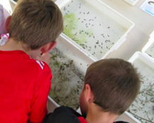
Open Air Laboratories (OPAL) surveys
Discover how this citizen science resource can be used to support communities in carrying out their own urban environmental surveys on a range of topics, including air quality, biodiversity, and water quality.
Research on Integrating Community-based Participatory Carbon Measurement and Monitoring with Satellite Remote Sensing and GIS in a Measurement, Reporting and Verification (MRV) System for REDD+
A summary of the Sumernet study on implementing an integrated community-based participatory and remote sensing measurement and monitoring system for REDD+ in Laos, Thailand, and Vietnam.
Adaption of grassland butterflies to climate change
Image: Traditionally managed semi-natural grasslands harbour a high biodiversity, and often also red-listed plants, butterflies and other insect species. Photo:...
Participatory 3D modeling for community-based climate change adaptation in BoeBoe community, Choiseul, Solomon Islands.
This video has kindly been released with the approval of the BoeBoe community. It shows some of the process and...