Cartagena de Indias System Description

System Description of Cartagena de Indias

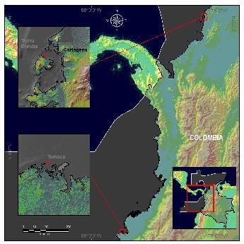
Cartagena de Indias Study Area
The Tourist and Cultural District of Cartagena de Indias, also known as La Heroica, is a large seaport on the north coast of Colombia. Founded in 1533 it was a major center of early Spanish settlement in the Americas, and continues to be an economic hub and, a popular tourist destination. The population of Cartagena is facing a transitional stage. The rural population growth rate is decreasing mainly due to population migration to the cities seeking better economic opportunities, and to forced displacements to the urban areas due to violence in the countryside. This dynamic has contributed significantly to urban expansion. According to the SISBEN , since 2001 the number of people living in poverty and unequitable conditions has increased, reaching 54% of the population of Cartagena by 2003.
Among Cartagena’s main economic activities are the commercial and artisan fisheries, trade, industry and tourism. The port of Cartagena exports 14% of the total tons of fish exported by the four main ports of Colombia, and imports 10% of the total tons that enter the country. In general, the trade balance shows an increasing tendency in tonnage handled over time due to the growth of exports and the stable behavior of imports (DNP, 2004). According to DANE, in 2003 about 34% of the employed population was working in the trade sector. In addition to trade, industry also represents an important economic activity in Cartagena.
About 30km southeast of Cartagena there is a complex of islands, peninsulas and inner water bodies that form the insular and continental areas. Within the insular area, the national protected parks Corales del Rosario and San Bernardo represent the largest protected marine area of Colombia. The principal inner water bodies within the continental area are Cartagena Bay, the Ciénaga de la Virgen and the Ciénaga de Juan Polo, all connected by a complex system of lakes and channels (Alcalda de Cartagena, 2000).
Weather conditions in the research area are characterized by low rainfall and mostly sunshine. Cartagena’s temperature ranges from an average high of 31°C to an average low of 24°C throughout the year. The average humidity in this area is approximately 90% with a wet season that extends from May to September with higher humidity in October, and a dry season from January to April. Cartagena receives about 100cm of rain a year and the rainfall average per month is 90mm (CIOH and CARDIQUE, 1998).

Monthly average precipitation. 1961-1990.
The waves that most frequently hit the coast of Cartagena Bay are produced by the wind coming from the northeast . The average height of these waves is 0.25m. The average height of the waves produced by the wind coming from the west is 0.5m. The marine currents in Cartagena Bay are about 0.05m/s and travel parallel to the coast until Bocagrande. In Bocagrande the currents are stronger reaching 0.10m/s, causing erosion of the coastline. The coastal area of Cartagena is influenced by a semidiurnal tide regime. There are two high tides and two low tides every 24 hours. The range between these is very short (max. 60cm) which categorizes the tide regime as micro-tide (CIOH and CARDIQUE, 1998). The sea-level in Cartagena is usually low at the end of April and increases during the wet season reaching its maximum level in October (Andrade and Barton 2000). This annual variation is around 40cm without considering the tide. Added to a high tide, this variation can produce an increase of almost 1m in the mean sea-level of the bay during daylight hours in October. This phenomenon causes the well-known annual floods of the low zones of Cartagena, overflowing pipes and opening the bar of the Ciénaga de la Virgen. Among the major disasters experienced in Cartagena during the 1990s, all have been related to atmospheric conditions. A total of 17 disasters were caused by the above discussed SLR (DESINVENTAR, 2005).

Erosive Coastline in Cartagena de Indias
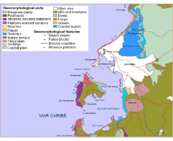
Cartagena’s coastal morphology is characterized by a deficit of sediments resulting in erosion of the coastline . This erosion process was induced by the jetty of Bocas de Cenizas built in 1936, causing the deposit of the Magdalena river’s sediments in a submarine canyon located in front of Barranquilla. The jetty is also a barrier to the natural coastal sediment transport between the Guajira and Cartagena. The evident coastal erosion and the interest to conserve the area’s historical and cultural patrimony motivated local decision-makers to implement protection measures some decades ago. However, the engineering work carried out has been developed without any specific plan and without any assessment of the potential impacts.
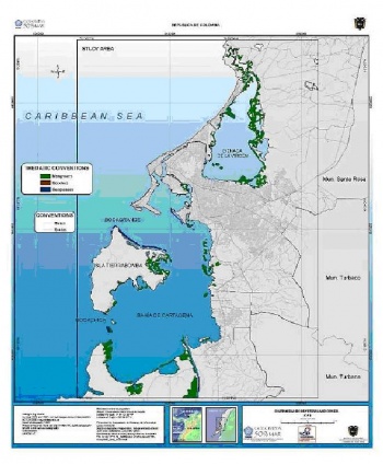
As a result of human activities and settlements, the ecosystems in Cartagena show different levels of degradation. In general, and particularly in the north and in the Ciénaga de Tesca, the ecosystems have been highly affected by extractive processes and unsustainable practices. The ecosystems in Cartagena include coral reefs, sea grass beds, mangroves, coastal lagoons, and beaches. Among them, coral reefs are the most visible and well studied. The most affected are sandy beaches and sea grass beds. Beach ecosystems are equivalent to 90% of the coastal profile of Cartagena. The main impacts on this ecosystem come from human activities over the past decade and erosion due to the strong winds coming from the north. Sea grasses are threatened mainly by the untreated sewage disposal and the continental water inflow. Mangrove ecosystems have also been heavily exploited in an unsustainable manner despite the services and resources they provide. It is possible to observe small relicts of mangroves surrounding the islands facing the industrial zone (Mamonal), on the borders of inner streams connected to the Ciénaga de la Virgen and on the borders of Tierra Bomba and Baru Islands. Mangroves also grow in some areas of the Channel of the Dike (CIOH and CARDIQUE, 1998).
Next. . .
Back to: Methodology of Colombia NCAP Project
Key findings from Colombia NCAP Project
On to: Lessons learned from Colombia NCAP Project
Source text
This article is sourced from the chapter “Building Capacity in Two Vulnerable Areas of the Colombian Coastal Area” in O’Brien, G., Devisscher, T., O’Keefe, P. (Eds.) (2010) The adaptation continuum: groundwork for the future. Netherlands Climate Assistance Programme (pp. 93-134)
(0) Comments
There is no content