Developing a social network map to frame adaptation action in the Guadiana river basin (Spain)

- Level: Advanced
- Time commitment: 1-2 hours
- Learning product: Worked example
- Sector: Water
- Language: English
- Certificate available: No
This socio-institutional network mapping exercise was conducted in the context of the EC FP7 Mediation project.
The following text is part of Deliverable 1.4: Visualization of institutional networks and the flows of information used for making adaptation decisions in a range of policy contexts and published in a paper here.
This article summarises the results of a stakeholder workshop conducted by the Technical University of Madrid (UPM) in the Guadiana basin (Spain) aimed at visualising networks using the NetMap approach (Schiffer, 2010).Further analysis is available here.
The Guadiana river basin has been selected as an illustrative example for the analysis of adaptation decision-making in the agricultural and water sectors. This basin is expected to be one of the most seriously affected by climate change in Spain, with a decrease in water resources of 11% by 2030. This is very important if we consider that irrigated agriculture is a major socio-economic driver in this area. The decrease of water availability could have important social and economic consequences, and adaptation becomes crucial to overcome the effects of climate change. With the aim of analyzing the social and institutional framework of climate change adaptation, the social network mapping exercise was applied with a group of stakeholders in the basin, including representatives of the most relevant stakeholder groups in the basin for water and agriculture: the water administration (River Basin Authority, Upper Guadiana Consortium), representatives of some of the main irrigation communities, of some of the most active environmental groups and representatives of the different climate change offices involved in the basin (the National Climate Change Office, the Climate Change Office of Castilla la Mancha Region and the Climate Change Office of Extremadura region).
For the analysis of the network, we focused on the following research question:
How are climate change adaptation related decisions taken in the Guadiana basin, in the agricultural and water sectors?
This question was the starting point for the analysis of actors who play a role in climate change adaptation in the Guadiana basin. Stakeholders, under the guidance of the UPM research team, described their perception of their network and the further analysis of this is presented below. Fifteen stakeholders attended the workshop, and they were divided in 3 groups of 5 people each, corresponding to: water administration, farmers and environmental organizations (including climate change offices). Each group built a socio-institutional network map, which was presented at the end of the day in a plenary session to explore different perceptions of the networks from the viewpoint of the different stakeholders represented. The strength of this exercise is that presenting networks back allows for an element of learning about other perspectives on the same problem since each group represents one stakeholder group. The networks built in each group are presented below.
Group 1: Water administration
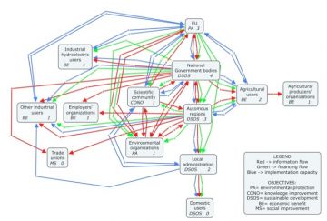
The first group was composed of officers from the water administration (dependent on the central government). Figure 1 shows the social network map built by this group. The boxes represent the different stakeholder groups involved in adaptation to climate change in the basin, and they contain: the name of the stakeholder group, their main objective (the abbreviation on the left of the box) and a number representing the influence of that specificstakeholder group on the problem addressed (on the right of the box; a higher number means higher influence). Those boxes are linked through lines of different colours, which represent different types of flows between stakeholder groups: flows of information, funds and implementation capacity.
In Figure 1 we can see that this group designed a hierarchical network structured in several blocks of actors: administrations, water users (agrarian and non-agrarian uses), trade unions, scientific community and environmental organizations. Administrations form a cluster in the middle of the network, while the other users are located around them and linked through the administrations, which are working as bridges (especially the European, national and regional levels). The number of links is quite high, showing a strong relationship between actors. This is a Type 3 network where uncertainty can be explicit, although it tends to be wrapped into how the organization is structured and procedures that are in place for other purposes.
With respect to flows, the public administration cluster is at the centre of information flow; the different administration levels are linked hierarchically and serve as links between the different types of users. The environmental organizations and the scientific community are also linked to the administration at different scales.
With respect to financial flows, they mainly go from the EU to the scientific community and to the central, regional and local administrations. From the central and regional administrations, there is a financial flow towards farmers and other industrial uses.
Implementation capacity (technical, institutional), flows from the EU to users and to the central administration, and from here to the autonomous regions, and then the local administration.
The actors with whom the central administration has strongest relationships (many and/or close ties) are the other administrations (EU, regional), the scientific community and the environmental organizations. Beyond these organizations, the administration is linked to all users. However, they feel that the link with users should be even stronger, as well as with the scientific community, the environmental organizations and local administrations. Discussion revealed the view that in order to improve these relationships, there should be more willingness to solve problems, increased participation, and further economic resources to backup compulsory environmental regulations. One of the weaknesses that could be addressed to improve connections with other actors is the need to establish a real participation body with an endorsed legal instrument, which guarantees responsibility of all actors.
With respect to the relative influence of actors in the network, the most important actor is the central administration, which has the responsibility to make the system work.
The group provided information on changes in the social-institutional framework that could improve decision-making in the domain of climate change adaptation:
- A reform of the legal framework.
- Elimination of overlaps in the different government offices’ competences (central administration and autonomous regions).
- A willingness to solve problems, improve communication, coordination and participation.
- Improvement of management by the irrigation communities (who have the funds and the capacity but do not administer them properly from the perspective of this group).
- Increase in participation of direct, non-economic beneficiaries of water (civil society, etc.), with responsibilities.
- Improved control of compliance.

Figure 2
Group 2: Farmers
This group is composed of 4 representatives of farmers (from irrigation communities and independent famers) and one researcher from an agriculture department. Figure 2 shows the social network built by group 2. As in the previous case, boxes represent the different stakeholder groups, containing the name of the group, its main objective and the influence they have on the adaptation problem (a higher number means higher influence). Coloured lines represent different types of flows between stakeholder groups.
This group has designed a more fragmented network, with a lower number of connections and some disconnected actors. Amongst the actors, they identify the different administrations, environmental organizations, scientists and two types of users: agricultural (irrigation and rain-fed) and others (domestic and industrial use). According to their perception, irrigators are strongly linked to the different administrations and, to some extent, to the environmental organizations and scientists. However, they do not act as a bridge, as they only have incoming flows. Like in the water administration group, it is felt that the relationship between the irrigators and the different administrations is maintained through the national and the regional administrations.
This is a Type 1 type of network where individual action predominates. While people are connected in various ways, on the issue of adaptation most of their actions are at their own level and independent of what others believe or are doing. In this type of network, there may be a diversity of approaches to uncertainty. The construction of the problem is usually highly constrained and mostly short-term with rather limited information on long-term futures.
With respect to information flows, they go from UNFCC to the EU, than to thecentral government, to the autonomous regions, and finally to farmers. With respect to financial flows, they go from the EU to the scientific community, on one side, and to the central government on the other; from this, funds go to the autonomous regions, and all administrations provide funds to farmers.
With respect to influence, the most important actors are the river basin authority and the regional department of agriculture. According to the farmers, environmental NGOs and unions have too much influence (height of the towers in the exercise), whilst the university and the rain-fed farmers should have more.
Comparing the goals of the different actors, we can see that there are conflicting interests between environmental NGOs and farmers. Although the group of farmers state that they have the triple objective of development, conservation and population stability, they state that NGOs are generally people with low level of formal training though very vocal, and thus perceive this group as a danger for the accomplishment of their own objectives.
Some areas that this group feels should change to improve the system are, first of all, an increase in trust, which is in general, too low. The river basin authority and the regional department of agriculture should take advantage of synergies. In the map, famers felt that rain-fed agriculture should be linked to environmental NGOs, and the university should have a more direct relationship with farmers too. Through the exercise it was also evident that there were missing connections that the farmers felt were important, such as those between irrigated farmers and rain-fed farmers, as well as with other water users. Other insights were that irrigation communities should be given more capacity for decision-making and action, as well as more training, more implementation capacity and greater funding should be distributed between the irrigation communities.

Figure 3
Groups 3: Environmental actors
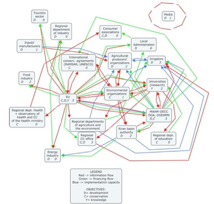
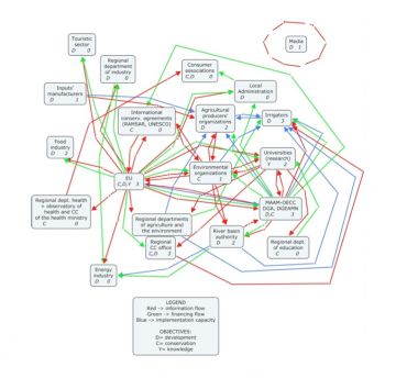
The third group is composed of members of environmental NGOs and officers from national and regional (Castilla la Mancha and Extremadura) climate change offices, which we have called ‘environmental’ actors. The network discussed by this group is displayed in Figure 3. As in the previous cases, boxes represent the stakeholder groups related to climate change adaptation in the agricultural and water sectors, and include their main objectives and their relative influence on addressing the problem. Between these stakeholder groups, several types of flows exist represented as lines of different colours.
This group designed a homogeneous network, with no evident clusters. The number of links between actors is high, and none of them is disconnected. This is a Type 2 egalitarian network where everyone tends to be ‘like-minded’ and the structure of the problem is similar across the network. Uncertainty may not be explicit but reduced to tacit assumptions common in peer networks and reflected in cultural and group norms rather than a science-policy dialogue as such.
With respect to flows, funds flow from the EU to the tourism sector (Leader funds) and from the Ministry of Agriculture, Food and the Environment-Spanish Office of Climate Change (MAAM) to the Agricultural Producers’ Organizations (OPAs; social funds from the EU). The EU is the main source of flows of information related to decision-making and implementation capacity flows from the OPAs to individual farmers.
According to the map, this group of environmental actors has the strongest links with universities, the EU and the river basin authority. They should in theory work closely with irrigators (hence their close proximity on the map) but they lack many connections with these irrigators, as well as with the regional government, international conservation agreements (such as RAMSAR), with consumers and with the tourism sector. The group mentioned that a possible way of strengthening links would be providing support and implementation capacity and improving the information given to consumers.
The most important connector in the network is the EU, though the MAAM and the regional government are also important, serving as a link (bridge) between the EU and other actors. Groups with few connections include the tourism and education sectors, local administration and inputs’ manufacturers (agri-food sector).
There many connections to the EU, which makes the system very much dependent on this actor alone. The power should be distributed further across the MAAM and the regional government, with the support of local organizations. Environmental organizations and the MAAM are highly connected and these links could be further strengthened and exploited. On the whole, this network is quite homogeneous, with few isolated elements: consumers’ associations, health, and the energy industry.
With respect to the influence, the most important actors for climate change in the Guadiana basin are the EU and the central government. Other relevant actors are irrigators, but more as a result of their impact on the implementation of adaptation measures, as well as regional government, irrigators and the MAAM. The least influential actors are the local administration, consumers and the education sector. There are some influential actors with whom this group is not well connected: consumers, OPAs and the tourism and health sectors and these would be important areas to address.
Looking at the goals of the different actors, we can see that there are two important conflicting objectives in the network: conservation and development.
Regarding possible ways to improve the network, this group can facilitate synergies by developing tools and strategies for raising awareness about climate change and continuing to involve the media.
Schiffer, E., Hauck, J. 2010. Net-Map: Collecting Social Network Data and Facilitating Network Learning through Participatory Influence Network Mapping, Field Methods 22(3): 231-249.
(0) Comments
There is no content